The fire hazard is high to extreme across the vast majority of the Northeast Region, while some places in the Far North, including Fort Albany and Attawapiskat, were showing a low to moderate fire hazard last night following some precipitation, according to a news release from the Aviation, Forest Fire and Emergency Services.
Areas located east and south of Mattawa are also showing a mostly moderate hazard.
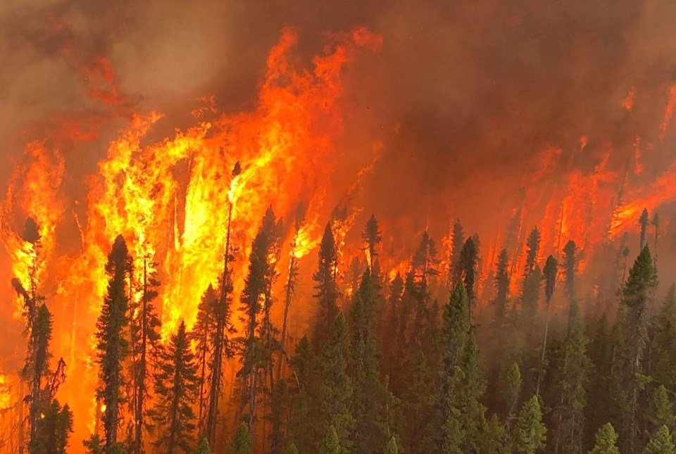
There are currently 28 active wildland fires in the region. Of these, 15 are not under control, six are being held, six fires are under control and one is being observed.
Following is the complete news release:
Aviation, Forest Fire and Emergency Services
Northeast Fire Region
June 24, 2023
Time of Report – 20:02
Northeast Region
There are currently 28 active wildland fires in the Northeast Region. Of these, 15 are not under control, six are being held, six fires are under control and one is being observed.
- Sault Ste Marie 8 is being held at 0.1 hectare. It is located 500 meters northeast of Karalash corners.
- Wawa 8 is being held at 0.5 hectares. It is located 3 kilometers west of Anahareo Lake.
- Cochrane 19 is 9 hectares. It is located 3 kilometers northeast of Chabbie Lake. It is not under control.
- Cochrane 18 is not under control at 6.1 hectares. It is located southeast of Little Wakwayowkastic Lake.
The fire hazard is high to extreme across the vast majority of the Northeast Region again today, while some portions of the Far North including Fort Albany and Attawapiskat are showing a low to moderate fire hazard this evening following some precipitation in the area. Areas located east and south of Mattawa are also showing a mostly moderate hazard.
Fires of note:
- Cochrane 7 was confirmed on June 2. It is a 18,400 hectare wildland fire is located northeast of Lake Abitibi. Intense fire behavior continues to be exhibited by this fire which is not under control.
- Cochrane 11 was confirmed on June 17. It estimated at 805 hectares and is located approximately 5 km west of the community of Fort Albany and south of Big Island. High fire intensity was exhibited on Wednesday and aerial fire suppression helped to lower fire activity on June 21. Today, a belly tanker helicopter continued to work in conjunction with crews on the ground on the active wildland fire which is not under control, with good progress being made.
- Cochrane 12 is located approximately 8 km west of Attawapiskat and measures 68.2 hectares. It has been responding well to fire suppression efforts and is not yet under control.
- Cochrane 16 is located approximately 8 km south of Moose Factory and is estimated at 4 hectares in size. It is not under control and two FireRangers crews are working to establish a hoseline around the perimeter of the fire.
- Chapleau 3 was confirmed on June 1. It is a 3,916 hectare wildland fire located 2 kilometres south of October Lake and 2.5 kilometres west of Vichaw Lake. It is not under control.
- Chapleau 6 was confirmed on June 4. It is a 1,239 hectare wildland fire located 2.5 kilometres west of Morin Lake and 1 kilometre east of Bolkow Lake. It is not under control.
- Sudbury 10 was confirmed on June 2. It measures 1,370 hectares and is located 3 kilometres west of Fox Lake and 5 kilometres east of Acheson Lake. It is not under control.
- Sudbury 17 was confirmed June 4. It is a 5,857 hectare wildland fire located 3 kilometres west of Madawanson Lake and 0.5 kilometres east of Pilot Lake. Multiple crews are committed to the fire. It is not under control.
Restricted Fire Zone in effect
A restricted fire zone remains in effect for the entire fire region of Ontario. Outdoor fires are banned.
In addition, we urge residents to use extreme care with any activities that could have the potential of sparking a fire, including parking or driving vehicles on dry grass or other forest floor susceptible to ignition from hot machinery (this can include cars, trucks, SUVs, ATVs, or other mechanical equipment).
Implementation Orders
Travel, use, and access Restrictions in the Northeast Region – MNRF Sudbury District
Under the Emergency Area Order (EAO 2023-04) declared on June 5, 2023, the MNRF Sudbury District has put in an Implementation Order to protect public safety and facilitate effective fire suppression. The following restrictions listed and as outlined on the Implementation Order map are now in effect until further notice:
- All travel and use of Highway 810 (also known as the Massey Tote Road) south of Ritchie Falls at UTM Zone 17 East 403972 North 5174771, and north of Madawanson Lake Rd at UTM Zone 17 East 409250 North 5158217 is prohibited unless authorized by a Travel Permit issued by the Sudbury District Ministry of Natural Resources and Forestry
- All persons are prohibited from entering the area indicated on the attached map unless authorized by a travel permit issued by the Ministry of Natural Resources and Forestry.
For more information on these restrictions, see the Implementation Order map. If you have questions regarding travel and access restrictions, please contact the Sudbury District Office at 705-564-7850.
Travel, use, and access Restrictions in the Northeast Region – MNRF Hearst-Cochrane-Kapuskasing District (COC005, COC006 COC007 fires):
- Under the Emergency Area Order (EAO 2023-03) effective June 5 at 7:01 a.m., 2023, the MNRF, Hearst-Cochrane-Kapuskasing District has put in an Implementation Order to protect public safety and to facilitate effective fire suppression. The following restrictions listed below and as outlined on the Implementation Order are now in effect until further notice. All travel and use of the following areas is prohibited unless authorized by a travel permit issued by the MNRF Hearst-Cochrane-Kapuskasing District:
- Translimit Road and Crossover Roads eastwards beginning where the roads intersect at UTM Zone 17 East 571137 North 5436902
- Translimit Road west of the Ontario-Quebec border at UTM Zone 17 East 608042 North 5423187 to the Translimit-Crossover Road control point
- Bingle Road south of where it intersects with the former CN Rail Line at UTM Zone 17 East 545352 North 5421478
- All use and occupation of Crown Land and roads within Marathon Township south of the former CN Rail Line
- All use and occupation of Crown Land and roads within Bowyer Township south of the former CN Rail Line
- All use and occupation of Crown lands and roads within the Townships of: Moody, Galna, Knox, Kerrs, Steele, Berry, Sargeant, Bonis, Scapa, Hepburn, Abbotsford, and Adair.
For more information on these restrictions, see the Implementation Order Map. If you have any questions or require travel permits, please contact the Hearst-Cochrane-Kapuskasing District office at 705-272-7178or by email [email protected]
Travel, use and access Restrictions in the Northeast Region - MNRF Chapleau-Wawa District (CHA003 fire):
- Under the Emergency Area Order (EAO 2023-05) declared on June 9, 2023, the Ministry of Natural Resources and Forestry, Chapleau-Wawa District has put in an Implementation Order for the CHA003 fire to protect public safety and to facilitate effective fire suppression. The following restrictions listed below and as outlined on the Implementation Order Map, are now in effect until further notice. All travel and use of the following areas is prohibited unless authorized by a Travel Permit issued by the Chapleau-Wawa District Ministry of Natural Resources and Forestry (MNRF):
- Dore Road (Foleyet Timber Road) south of UTM 17 North, East 381644, North 5300986
- Jerome Road north of the Sultan Industrial Road, UTM 17 North, East 396782, North 5266107
- Mallard Road north of the Sultan Industrial Road, UTM 17 North, East 395324, North 5266100, and
- Dore Road (Foleyet Timber Road) north of the Sultan Industrial Road, UTM 17 North, East 387440, North 5273197.
For more information on the travel and use restrictions, see the Implementation Order Map. If you have any questions or require travel permits, please contact the Chapleau-Wawa District Office at 705-856-2396
Help fight forest fires: Stay clear of waterbombers!
When waterbombers approach a body of water, move close to the shore so they can perform their scoop safely. A waterbomber will not scoop from a lake or river if encroaching watercraft pose a safety hazard. Be safe, stay clear of waterbombers.
No Drone Zone: Be safe, stay clear of forest fires!
Flying drones around forest fires is both dangerous and illegal. When you fly a drone near a forest fire, you can put the lives of pilots, firefighters and other emergency personnel at risk. Be safe, stay clear of forest fires.
Report a Wildland Fire
To report a wildland fire located north of the French and Mattawa rivers, please dial 310-FIRE. To report a forest fire located south of the French or Mattawa rivers, please dial 911.
For tips on preventing wildland fires and information on the current fire situation, follow us on Twitter in English and French @ONforestfires and @ONfeudeforet.