The air quality index for the North Bay area has reached dangerous levels.
Above 300 indicates a health warning of emergency conditions and everyone, not just those at risk, is more likely to be affected with 24 hours of exposure.
At one point this morning the index stood a 519, which is at the top of the chart. For comparison, an AQI of 100 is the upper end of the “Moderate” range, and the level above at-risk groups should start exercising caution
This morning Sudbury is at 355.
Here in Elliot Lake it's not quite as bad, but a special air quality statement remains in effect Sunday.
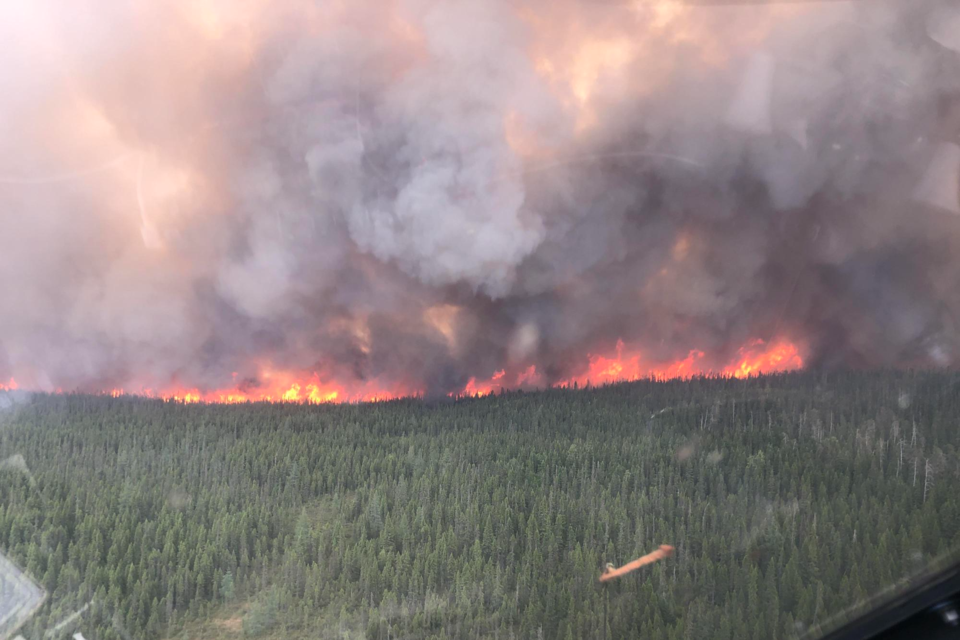
There is also heavy smoke in the Timmins area today.
The smoke conditions are due to the fires in Northern Ontario, Quebec and western Canada, says Aviation, Forest Fire and Emergency Services (AFFES). Due to the high levels of air pollution, Environment Canada's special air quality statement remains in effect.
The smoke can fluctuate over short distances and may also impact visibility.
"Wildfire smoke can be harmful to everyone’s health even at low concentrations. Continue to take actions to protect your health and reduce exposure to smoke," says Environment Canada.
As of yesterday evening (June 24), there were 28 active fires in the northeast.
Two of the four new fires reported June 24 were in the Cochrane district. Cochrane 19 is nine hectares and is located three kilometres northeast of Chabbie Lake. Cochrane 18 is 6.1 hectares and located southeast of Little Wakwayowkastic Lake. Neither of the blazes are under control.
All of the six fires reported in the Watabeag Lake area on Friday, June 23 are now being held. The details on those, according to AFFES, are:
- Kirkland Lake 8 is 1.9 hectares. It is located near the north shore of Watabeag Lake and just east of Brown Lake.
- Kirkland Lake 9 is 0.5 of a hectare and is located along the southwestern shore of Watabeag Lake.
- Kirkland Lake 10 is 0.8 of a hectare and is located northwest of Watabeag Lake.
- Kirkland Lake 11 is located on the west side of Watabeag Lake and 1 kilometre south of Toy Lake. It measures 0.4 of a hectare.
- Kirkland Lake 12 is 1.9 hectares and is located near the southwest shore of Watabeag Lake, approximately half of a kilometre southwest of Big Island.
- Kirkland Lake 13 measures 0.2 of a hectare and is located approximately half of a kilometre east of Leziert Creek on the southwest side of Watabeag Lake.
Other notable fires in the district that are not under control include:
- Cochrane 7 was confirmed on June 2. It is 18,400 hectares and located northeast of Lake Abitibi. Intense fire behaviour continues to be exhibited by this firel.
- Cochrane 11 was confirmed on June 17. It is estimated at 300 hectares and is located approximately 5 kilometres west of Fort Albany and south of Big Island. High fire intensity was exhibited on Wednesday and aerial fire suppression helped to lower fire activity on June 21. Yesterday, a belly tanker helicopter continued to work in conjunction with crews on the ground on the active wildland fire which is not under control, with good progress being made.
- Cochrane 12 is located approximately 8 kilometres west of Attawapiskat and measures 68.2 hectares. It has been responding well to fire suppression efforts.
- Cochrane 16 is located approximately 8 kilometres south of Moose Factory and is estimated at 4 hectares in size. Two FireRangers crews are working to establish a hoseline around the perimeter of the fire.
- Chapleau 3 was confirmed on June 1. It is a 3,916-hectare fire located 2 kilometres south of October Lake and 2.5 kilometres west of Vichaw Lake.
- Chapleau 6 was confirmed on June 4. It is a 1,239-hectare fire located 2.5 kilometres west of Morin Lake and 1 kilometre east of Bolkow Lake.
- Kirkland Lake 7 is located eight kilometres north of Lady Evelyn Smoothwater and 10 kilometres south of Highway 65. It started June 7 and is 2,300 hectares.
The fire hazard across most of the northeast region remains high to extreme. In Timmins, an open-air burn ban remains in effect.