I'm in the planning stages for a future story about the Nipigon River Bridge that hinges on a strategic location and some infrastructure history.
Seventeen million kilograms is the average total weight of goods transported daily across the iconic Bridge.
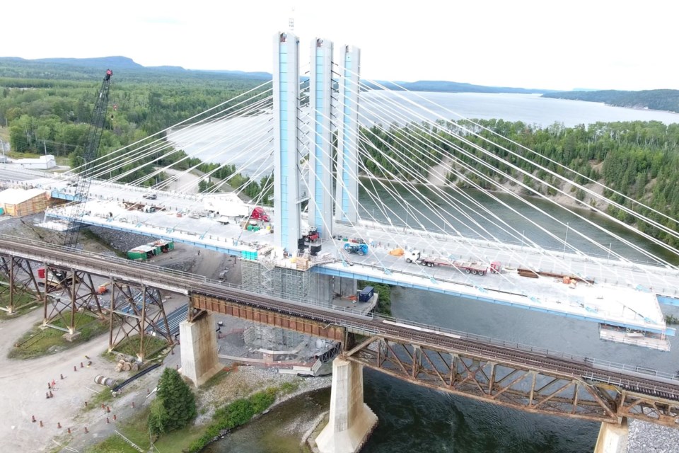
That's the same weight as more than 1,100 large African elephants. And the radial-like design looks like the maritime longline fishing technique with a main line, with baited hooks attached at intervals.
That’s also where two Trans Canada Highways merge, #11 and #17. Why do we have two Trans Canada Highways? And why do the transcontinental railways have two different routes across the north? History may be catching up with future developments, which will be part of this story.
Important premise
If there was a natural disaster or if you were a nefarious terrorist and wanted to strategically plan a transportation and economic destructive impact it would be at the Nipigon River Bridge where Highways 11/17 and the expansive CPR railway bridges merge. This fording location on the north shore of Lake Superior is the one place in Canada where there is only one east-west crossing to move in both directions.
More than 5,300 vehicles cross the bridge each day including 1,600 commercial vehicles carrying more than $100 million worth of food, petroleum and other consumer/manufactured goods, according to the Ontario Ministry of Transportation.
The success of the country's commercial transportation network hinges on the Nipigon River Bridge, a vulnerability exposed when the northern Ontario crossing heaved and broke on Jan. 10, 2016, and severed the main trucking route between eastern and western Canada.
The west side of the bridge pulled away from the abutment connecting it to the riverbank’s edge, lifting up about 60 centimetres.
"It's not just us. It's all of Canada that has a problem right now," then, Nipigon Mayor Richard Harvey told the National Post.
"This is the one place in Canada where there is only one road, one bridge across the country," the post quotes him as saying. "Engineers are on site trying to determine what caused the bridge to fail, but the reality is nobody really knows what happened.”
We now know a combination of design and installation deficiencies of several key components caused the bridge to fail, 42 days after it first opened. Two engineering reports found that improperly tightened bolts on one portion of the Nipigon Bridge snapped, causing the steel decking to lift. This remains a concern for the future.
Is there a way around this strategic point?
Let's look at some history first, that’s important to the future story and the back roads challenge. Keep in mind we have two Trans Canada Highways in northern Ontario, that emanate in North Bay, join back in Nipigon then split northwest of Thunder Bay and then join again east of Kenora.
And we have two railways, the CPR and CNR, that have different routes between Sudbury and Winnipeg.
Highway 17
Readers have most likely travelled Northern Ontario utilizing Highways 11 and 17. We know the bumps, the ups and downs and the seasonal challenges of traversing the Canadian Shield.
King's Highway 17, more commonly known as Highway 17, is a provincially maintained highway and the primary route of the Trans Canada Highway through Ontario.
It begins at the Manitoba boundary, 50 km (31 mi) west of Kenora, and the main section ends where Highway 417 begins just west of Arnprior.
With a peak length of about 2,180 km (1,350 mi), a section of Highway 17 disappeared when the Ottawa section of it was upgraded to the freeway Highway 417 in 1971.
It is the sole highway linking the eastern and western regions of the country. This makes it Ontario's longest highway. The northern Ontario section was not completed until 1960 in Wawa
Highway 11 North
In second place is the King's Highway 11, commonly referred to as Highway 11. It is 1,784.9 kilometres (1,109.1 mi) in length.
Highway 11 begins at Highway 400 in Barrie and arches through northern Ontario to the Ontario–Minnesota border at Rainy River via Thunder Bay. The road continues as Minnesota State Highway 72 across the Baudette–Rainy River International Bridge.
North and west of North Bay (as well as for a short distance through Orillia), Highway 11 forms part of the Trans-Canada Highway. The highway is also part of the tourism route MOM's Way (historically the Dawson Trail – 1871) between Thunder Bay and Rainy River.
The original section of Highway 11 along Yonge Street was colloquially known as Main Street Ontario.
Highway 11 became a provincial highway in 1920 when the network was formed, although many of the roads that make up the route were constructed before the highway was designated. At the time, it only extended between Toronto and north of Orillia. In 1937, the route was extended to Hearst. The route was extended to Nipigon by 1943. In 1965, Highway 11 was extended to Rainy River, bringing it to its maximum length of 1,882.2 kilometres (1,169.5 mi).
From the late 1940s through the 1960s, numerous bypasses of towns along the route were built, including Orillia, Washago, Gravenhurst, Bracebridge, Huntsville, Emsdale, Powassan, Callander, North Bay, Cobalt, Haileybury, New Liskeard and Thunder Bay.
Beginning in the 1960s, the highway was four-laned between Barrie and North Bay in stages. Four laning was completed between Barrie and Gravenhurst in the 1960s, between Gravenhurst and Huntsville in the 1970s, and from North Bay south to Callander in the 1980s.
The remaining two-lane section between Huntsville and Callander was four-laned through the 1990s and 2000s, and was completed in 2012, it is thought to be a Premier Mike Harris legacy, as he also represented the riding of Nipissing.
A section concurrent with Highway 17 east of Thunder Bay was rebuilt as a divided highway in the early 2010s and work continues. The two-lane Nipigon River Bridge was replaced with a twin-span bridge that opened in 2018, following a structural failure in 2016 located at the junctions of the two Trans Canada Highways.
Highway 11 was completed in June of 1943. And it is a long stretch between Hearst and Longlac.
Railways
Just for good measure, one should look at a map to see the routes of the CNR and CPR railways that cross northern Ontario, particularly from Sudbury to Winnipeg.
Historically, the ‘National Dream’ of the CPR took a lower latitude and more costly route that hugs the steep and rugged shore of Lake Superior. Part of the reason why was proximity to the Great Lakes shoreline where most of the communities evolved from and were also served by steamships. The main river crossing for the CPR is at Nipigon.
The CNR, (formally known as National Transcontinental Railway) which is now Canada’s largest railway company diverges and roughly follows Highway 11 North for a bit and west of Hearst veers to the NW around the north end of Lake Nipigon, towards Savant Lake and Sioux Lookout and then westward to Winnipeg; it is in essence a shorter route, given the curvature of the Earth.
Futuristic
In a Northern Ontario Business article, Five big ideas for Northern Ontario - Sept. 25, 2017, Charles Cirtwill, president and CEO, of Northern Policy Institute identified an interesting new future and realistic concept based on all of the above.
“One, connect Highway 11 through Aroland to Armstrong and over the top of Lake Nipigon to Savant Lake," Cirtwill said in the article. "If we are serious about a dedicated truck route, electronic vehicles, and creating a true transportation grid, that will do it. If the bridge at Nipigon is ever blocked again, the country will not be cut in half. Such a route also opens up the mid-north and would tie nicely into the proposed infrastructure for the Matawa communities and the Ring of Fire.”
“Two, let’s explore a high-speed train from Toronto to Edmonton with stops in Timmins, Aroland, Red Lake and Winnipeg for starters.
"Trains are making a recovery in much of the world due to better emissions control, fuel efficiency and, frankly, comfort. High-speed trains cover long distances while servicing major centres.
"We have large population centres separated by large distances, and the ability to slot in one or two stops along the way to increase the options for the rest of us.”
It is somewhat uncanny we are revisiting history and looking at the future.
He went on to summarize.
“The best part of all of these big ideas is that none of them are new or unproven. The Trans Canada rail and road network, the interstate in the U.S., and the Autobahn in Germany all demonstrated the efficacy of these types of projects to spur growth and sustain prosperity.”
The challenge
So, what’s the challenge Bill?
Here is a complementary question following all this prose. There are a myriad of logging roads in northern Ontario.
At the top end of Lake Nipigon, there are main haul roads east of Armstrong (on the CNR Line) and these merge towards the forest road network north of Geraldton.
In keeping with Charles Cirtwill’s thought do these logging roads join? From the map and sources contacted it appears there is about 1-2 km of remaining bush or they do actually join with a couple of bridges out or removed (a forest management plan practice).
This answer would help with any Nipigon bridge closure and lay the groundwork for a more direct east-west transportation corridor and service the developing Ring of Fire.
It is not a stretch to connect this northern join, around the top of Lake Nipigon, continuing westward to Savant Lake to Sioux Lookout, Highway #519 exists.
To make sense of all of this, the map will help. Take the time to pan and zoom in and out.
Yellow is the CPR; blue is the CNR; purple is Highway 527 to Armstrong and the red pins represent the potential link around the north end of Lake Nipigon via existing logging roads (that’s the challenge).
You can easily see Highways 11 and 17.
Green pins are for Highway 17 (Lake Superior route for the Soo).
At White River the highway goes inland to Marathon and then roughly follows the CPR westward. You can follow Highway 11 – the northern route - from North Bay to Cochrane through Hearst to Nipigon. You will identify the approximate area of the mineral-rich Ring of Fire deposit between Marten Falls and Webequie First Nations.
There are not too many elephants crossing the Nipigon River Bridge. Maybe it was a white elephant when you consider how over budget and how high the repairs turned out to be. You can’t even fish from the bridge. The back roads may have a new answer of where we go next.


