If you have ever worn a full recreational driving helmet you know the scratchy scraping sound of the speckled alder twigs hitting the visor and the side of the helmet. Then there is a louder lower, resonating sort of thwack when it is a larger balsam fir branch; indicative of trying to move through overgrown and seldom used trails.
The destination is a remote and sacred pictograph site; it would be a longer canoe trip so the opportunity to do some back country snowmobiling sounds like a plan, and there was no need for any McKirdy’s repellent for the bugs see two weeks back. It is one of those reflective times when the trek becomes a journey.
Context
Access to this portion of the Lady Evelyn- Smooth water wilderness area is Highway 805, it is a 52.5-kilometre (32.6 mi) route located northwest of Sturgeon Falls and River Valley which serves as a resource access road, designated in 1962 that was an access to the once operating Golden Rose Mine (1915-1941 and 1987-1991) near its terminus.
There are no established communities along the highway, but is an access to where we are headed.
The route begins at a junction with Highway 539A next to the Sturgeon River, near Field, and travels north from that point. Because of the rugged terrain of the Canadian Shield, the winding highway crosses between Sudbury District and Nipissing District several times, but generally serves as the boundary between the two.
MTO statistics indicate that on an average day, less than 100 vehicles travel along the route. There had been a heavy snowfall the day before, Family Day, it was slow going, we passed the snowplow in the morning and on the way out saw two moving cars.
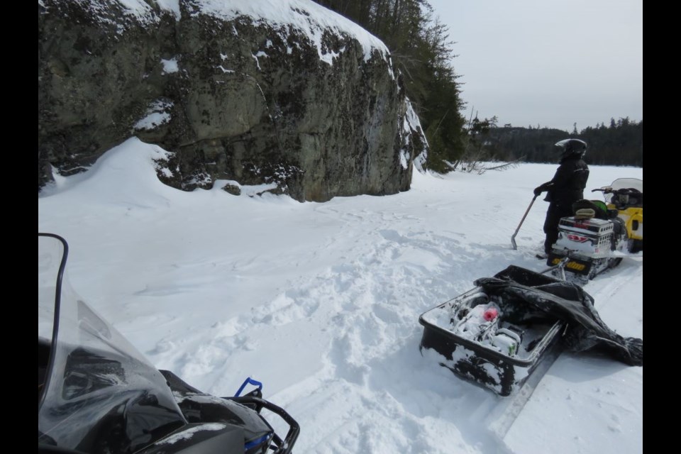
There are some expansive views of Manitou Lake as the narrow road climbs up and down the shoreline.
The Temagami Area Park Management Plan, approved in 1994 includes the Lady Evelyn-Smoothwater, Makobe-Grays River, Obabika River, Solace and Sturgeon River Provincial Parks.
The Temagami area, located 100 km north of North Bay, covers approximately 650,000 hectares of varied and rugged terrain. Five provincial parks covering 104,248 hectares lie in the western part of Temagami. Surrounding the parks are eight conservation reserves which make up an additional 42,836 hectares of protected area.
The remaining land base consists of unregulated Crown lands. Much of the area is relatively remote, offering solitude and challenge for those seeking a backcountry recreation experience.
Temagami has been a tourist destination for over a century, and with over 2,400 kilometres of interconnecting canoe routes and portage trails, called “Nastawgan” it is considered one of North America’s premier canoeing destinations. The area attracts local residents as well as visitors from provincial, national and international markets.
For more than 6,000 years, aboriginal inhabitants have lived in the Temagami area, travelling by way of an interconnected system of winter and summer trails and portages. Temagami lies within Daki Menan, the ancestral homeland of the Teme-Augama Anishnabai—the deepwater people. Many sacred sites are found within the area, and the landscape of Temagami continues to hold great cultural, spiritual and economic significance for First Nation communities.
A strong tradition of stewardship continues today through ceremonies, culture and language, and the spirit of the land is cared for by the original keepers of the land. We are headed into the North Yorkston Conservation Reserve, west of Obawbika S. (Lake Obabika) and north of Kawcheekawbkiggaming (Yorkston Lake). See the Craig’s ethnographic map story from a few weeks back. There is a pictograph site on Asabbee S. (Ochre Lake) that seems to be out of place (?). The importance of ochre is documented here from June 20, 2020.
There are no groomed or signed trails here it is a chance to test your ability while exploring new terrain. It is a network of primary, secondary, tertiary and once used logging roads; there are no winter operations here this year and the other access are the indigenous portages of the Nastawgan, connecting lakes. The importance of such roads is highlighted here.
The only handmade sign you will see en route is the turnoff north to Alex Mathias, Misabi family Head, and Ojibwa elder from Temagami First Nation. He lives away from Bear Island with his family in their ancestral unceded tribal territory, at the north end where O-bawb-ika (Obabika) River flows out of Obabika Lake; he maintains the winter road north. It is here you turn Northwest, you are now on your own.
At the beginning, we do pass log piles destined for spring pick up and headed to the Goulard Lumber in Sturgeon Falls. But the trails are the seasonal souvenir of single, bumpy and hummocky tracks used by ice fishers from West Nipissing and Sudbury. At most the speedometer might reach 40 kph if you are lucky. We have to move NW from the end of 805 so any North-South lakes help make headway.
Here you are making your own tracks through the fresh snow or following the faint reminders of others “headed to camp” or fishing lakes. The trails are narrow with lots of heavy-laden snow branches and bows; you won’t poke your eye out with the helmet/visor; here it is dead slow but with enough acceleration to not waiver off the single track while ducking under the branches.
There is a myriad of orange flagged trails, each new trail corner looks like the one you just went around, even with the paper maps and GPS it is like a maze, with lots of false leads. What took us 71 km going in became 43 coming out. You do get stuck and these are not light machines; you have to have a reverse. Climb off your sled takes a half step off your track, you are immediately in waist-deep snow; there is a soft expletive and then gentle laughter as you can’t really move. The toboggan is full of emergency gear.
The challenge of the day was the slush a kind of a silent enemy. Besides insulating the ice, the snow when it gets too deep and heavy, forces water up through cracks resulting in slush hidden below the surface of the snow. Getting stuck in snow is bad enough; getting stuck in slush takes the misery to a whole new level. As you feel the back end of the machine break through, it is a reminder to stay heavy on the throttle; you don’t dare stop and it is worse coming back. You realize why the OFSC (Ontario Federation of Snowmobile Clubs) move most of their trails away from water.
Pictographs
You will recognize Jonathan Pitt’s name from other stories. Dr. Jonathan Pitt is an Indigenous knowledge keeper and is of Anishinaabek and Haudenosaunee heritage. Cultural transmission is part of his research and the courses he teaches at Nipissing University through Aki or land-as-teacher. He also works as an independent consultant for post-secondary organizations as an Indigenization Advisor.
Most recently the rock fairies and before that one of the pictograph stories. He knows, and is in tune with cultural heritage, he is a mentor.
Here is some background from a 2015 story with Dr. Pitt. Pictographs or what some call the “marking of the rock” often came from vision and dream ceremonies (e.g. at sacred sites such as Dreamer’s Rock (near Whitefish River First Nation) to represent that vision or dream of the artist from the Creator. After the vision or dream, habitually these ceremonies had a spiritual advisor (e.g. medicine man) who would assist the dreamer to interpret their dream before using ochre to create a pictograph.
There is also some oral history (e.g. storytelling) to suggest that pictographs were used ceremonially to ensure good hunting or health. Some Elders say that pictographs become one with the rock or grandfather. Mukwa (Ojibwe for bear) grease or fat is used by the Anishinaabe for drums and also was used with ochre when ground to a fine powder for painting pictographs which then underwent a chemical process to unite with the rock.
For Indigenous peoples, these pictographs are sacred. I was troubled seeing advertisements online for winter hikes promoting visiting similar sacred sites in winter as the advertisement showed someone touching the pictographs, which was very concerning. Pictographs are not to be touched; those involved with the advertisement ought to have known better.
When we look at the Anishinaabe Medicine Circle and the teachings I have been given, we must remember that Medicine Circle teachings vary based on geographic location and are a knowledge system or way of knowing, they are not universal. I can share only what I know.
The medicine circle teaches us to live in a good way and about balance in our lives, something that if we look at the fast life in the world today is clearly missing from the westernized modern world.
Of the four directions, the North is known as Giiwedinong depending on dialects, (various spellings). The North is represented by the colour white and winter, in our life cycle it is when we are elderly, during winter months prior to colonization we would break into smaller family units at this time of year, it was a time of rest. This allowed us to avoid sickness and not to over-deplete food sources.
During winter we would slow down and share stories, teachings and history. Often our Elders shared these stories and they are often represented in the North.
Just as we age we tend to be more reflective and look back on our lives, so too winter was this time for us, to reflect and rest our physical bodies. Our Mother Earth or the land/Aki also rests during winter; many animals such as Mukwa/Bear are also resting at this time.
Asabbee S. – Destination
It takes longer to reach Asabee S. (Ochre Lake) because of getting turned around a few times and the slush.
Upon reaching the far northwest end of the lake you spy the only place the pictographs could be, a distant, bulbous rock face to the southwest, anticipation builds.
The red pigment is magnetic, it stands out from a distance and the “glad to be there” thought leads to the “sense of knowing.”
An indigenous person was here at some time approximately three hundred to one thousand years ago; no one really knows. The location is much like all the others I have visited, a smooth rock face, protected by an overhang facing west.
The rock face is extensive but it is as if they knew where the best place would be to stand the test of time; each location is mostly like this one. There are three different groupings spread out along the snow line, a stone canvas with someone sharing their thoughts, perhaps as part of a vision quest.
There are some painted finger drags and what looks like a moose but it is the human-like figure that catches my attention. The north wind is bitter, there is a wind chill, having your gloves off to work the cameras is momentary; it is quickly time to head back after leaving some gratitude.
That night upon I immediately took the best frames off of the camera and send the pics to Dr. Pitt.
“If there is a head with horns or antlers it could be perhaps linked to ceremony or a shaman, it could also be related to hunting practices, as mooz have been and are central to Anishinaabe (and Cree) traditional practices," he responds. "I think these possibilities need to be included. In this case, it could be someone who was on a Spiritual journey and with the help of an Elder or Medicine Man interpreted their vision or dream.”
Dr. Pitt indicated that a friend of his, a Nishnaabemwin language keeper, noted that this is perhaps an older protoalgonguin word, a fuller meaning of the word "nets" for the name of the lake.
Dr. Pitt went on to say, "When MacDonald made the map he likely met with Spiritual leaders/Medicine people who often use an older language such as this in ceremony, i.e. sweat lodge."
Post Trip Thoughts
I am entering the wintertime of my life and nature remains the Vitamin N I know has been the best medicine. I think I saw myself in that one human-like morph and recognize the wise words of Jonathan; I am on that journey. These pictographs are in right place.
After leaving the slush, there is a little less anxiousness. Really wanted to stop for the readers and take a photo of all that slush, but that would have been a mistake.
That constant Ski-Doo sound of the Rotax engine puts you in the moment, there is that feel and smell of the snow machine, I am not an experienced rider, a little out of my element; most times I am on foot, in a canoe, on snowshoes or on a mountain bike. I start writing the story in my mind and consider some mental jot notes.
Did not get thwarted like the Bill Barilko crash site attempt, earlier this winter, so accomplishing something that takes some planning and risk management is always satisfying despite the slush.
You do think about the “what if’s” it is about 50 km back (given you are not snowshoeing on the slush filled lakes) to a vehicle, not much of a chance meeting someone on any of these trails late in the pm; but because I teach outdoor experiential education I prescribe to the notion of: “If you fail to plan, you will plan to fail.” That’s why you have the Garmin emergency inReach satellite communicator/locator device and you pay for the service.
In our ride back to Sturgeon Falls, tired and still pumped co-adventurer Brian Emblin from Timmins mentioned, “Did you see that open water we crossed over on Yorkston; didn’t see it because of the snowdrifts, we were going fast enough though?!”
Here is the trip map.
Some people ask me if I am ever afraid in these remote circumstances my answer is: “I am only afraid of missing out on something special in nature.”
This story is dedicated to the late Kevin Pinkerton who passed away this past summer as a result of a tragic home accident; I thought of him during this day as we had been in the Temagami backcountry a number of times. At the time he was the Ontario Parks’ Superintendent of all these parks, a lovely person, he helped me with many outdoor stories.
Your thoughts are a pilot of your life journey; the map is not always there to guide you. Not sure if the spirits within these pictographs wanted us to drop by on Family Day but we were glad to visit and pay our respects on the back roads.