On the back roads, we sometimes come across twisted bits of metal and concrete telling us something was there in the past. There are, for example, many old mines and logging camps on the landscape.
So quickly, it seems though the trees grow up, surrounding and hiding what was.
Industrial archaeology is the systematic study of material evidence associated with the industrial past. This evidence, collectively referred to as industrial heritage, includes buildings, machinery, artifacts, sites, infrastructure, documents and other items associated with what was.
Most likely our best Canadian example is the Rideau Canal or the Inglis grain elevators in Manitoba. And in northern Ontario, Cobalt is a rare cultural landscape consisting of vestiges and buildings associated with the evolution of hard rock mining in Canada in 1905.
Most of the time though, we demolish our industrial institutions to make way for progress or to remediate the environment.
Radar evidence
After the end of the Second World War, the world was quiet, but not for long.
In the 1950s, as the Cold War and the threat of airborne nuclear attack on North America developed, it was clear that Canada, located between the Soviet and American superpowers, would become the front lines of any attack.
Defending against any intrusion into Canadian airspace was the best way to guard against the possibility of Soviet bomber aircraft, and this was done by building dozens of radar stations across the country, creating three different lines or “fences” of radar coverage from coast to coast. And this includes many locations in Northern Ontario.
The word radar is actually an acronym for Radio Detection And Ranging but the acronym has become so commonly used it has become a word. Radar is a system for detecting the presence of, direction, distance, and speed of aircraft, by sending out pulses of high-frequency electromagnetic waves that are reflected off the object back to the source.
These “fences” were called the Pinetree Line, Mid-Canada Line (active until 1965), and Distant Early Warning (DEW) Line.
Collectively, these radar lines were responsible for providing accurate information on the current situation in the skies and were critical pieces of the system until they were removed or replaced.
One story of the Cold War, is about the Ground Observer Corps, who watched the skies for aircraft from 1951 to 1964 as the radar stations that would become the defence of Canada were built across the country.
Then came the radar stations built from coast to coast. Resources and personnel were shared between Canada and the United States for the construction and operation of the Canadian radar stations.
These radar stations became a part of the larger organization of NORAD (North American Aerospace Defence Command), which was made official in 1958. NORAD is the bilateral relationship between the United States and Canada for the purpose of air and aerospace defence. It is under NORAD that all aircraft were identified and monitored throughout the Cold War, and is still operational today.
For these radar stations to be effective, their locations were carefully and scientifically chosen based on topography and relative distance from other radar stations.
The radar needed to be able to see approximately 320 km (200 miles), thus requiring either a high altitude or wide open spaces. Some stations were fortunate to be located near existing communities, however, many would need to be carved out of the Canadian wilderness.
Ramore
Life at a radar station, like any other military posting, was influenced by many factors, such as its location, proximity to surrounding communities, geography and weather, but each also had its own unique community flavour.
While radar sites were comparatively smaller than most military installations, they were nonetheless relatively self-contained close-knit communities, starting their own sports teams, hobby clubs, children’s groups, schools, festivals, holiday events and recreation centres.
By 1950 construction began on a series of radar stations along the Pinetree Line. Ramore Ontario was one example.
Located about three hours north of North Bay, it is north of Kirkland Lake and south of Iroquois Falls. It is a good visit because of the before and after photos. Access is through a long and winding road from where the residences and operations were located up to the radar base at the highest elevation.
The Ramore station was constructed between 1950 and 1953 by the United States Air Force.
By the early 1960s control of the station was turned over the Royal Canadian Air Force. RCAF Station Ramore as it was renamed upon RCAF takeover used the SAGE (Semi-Automatic Ground Equipment) radar technology.
Data from Ramore would be relayed to RCAF Station North Bay which would either launch manned interceptor aircraft or deploy the nuclear-tipped Bomarc Missiles.
The bases were built to be able to track and identify threat aircraft, mainly from the Soviet Union. Collectively, they could provide a big picture of what was going on across a large area of Canada. As of 1963, they could filter to SAGE sectors, one of which was located in North Bay.
As technology progressed, the radar stations no longer required the staff to keep them running, and they are now remotely operated, but still centralized in North Bay.
Technology changes everything and soon the bomber threats became missile threats. The Distant Early Warning (DEW), now the North Warning System, came into existence. The two others were transitioned out of service.
After the Department of National Defense de-commissioned the station in 1974 it was transformed into a private retreat known as Lava Mountain Lodge. The enterprise soon collapsed and many of the old structures were demolished. Oddly enough the radar tower still stands at the top of Lava Mountain. The property was for sale.
Access is from Highway 11, east on to Highway 572, immediately turn south into Ramore and drive parallel to the railway tracks until you come to Lava Mountain Rd. It is 4 km to where the guard house/entry point remains. Proceed on the road past, drive another 4 km through the jack pine to the top of Lava Mountain and you will see the remains of the building where the radar dish and white geodetic dome would have been mounted; there is a good view to the south and west.
Reminders – Falconbridge/Armstrong
There remains one example of a radar base in Canada where the infrastructure has not been entirely demolished or trashed. Canadian Forces Station Falconbridge (CFS Falconbridge) was a military radar station in the Canadian province of Ontario, active from 1952 to 1985.
CFS Falconbridge was closed when the Pinetree Line was declared redundant in the mid-1980s. The station was sold to a private real estate developer in 1987. The residential part of the base is now a commercial rental housing development, and the radar operations building was torn down in 2007.
To have a look take Regional Road #85 from Sudbury out to Garson/Falconbridge and turn left at the sign to Skead/Coniston/Hanmer. This becomes Radar Road, aptly named.
Note: The only way in is through the gate at Pinegrove. The homes were improved and the deteriorated buildings were sealed up to prevent intrusion. Most were turned into rental storage buildings.
Opened in 1954 as Armstrong Air Station of the United States Air Force; in April of 1963 Armstrong was connected to the Semi-Automatic Ground Environment (SAGE) system, and the station became a long-range radar site. It is east of King St. in Armstrong, at the end of Highway #527, 235 km north of Thunder Bay.
From an excerpt from ‘Canadian Military History,’ by Bruce Forsyth, “Corresponding with the SAGE conversion, the station was handed over to the Royal Canadian Air Force and re-named RCAF Station Armstrong. This was part of an arrangement with the United States that came as a result of the cancellation of the Avro Arrow. Canada would lease 66 F-101 Voodoo fighters and take over operation of 12 Pinetree radar bases.”
Improvements in radar technology made the site redundant and the station closed in September, 1974.
“A recommendation had been made in May 1974 by the last commanding officer of the station, Lieutenant-Colonel J.A. Mitchell, to Air Defence command Headquarters at RCAF Station North Bay, that the Department of National Defence make the property available to the Department of Indian Affairs and Northern Development for use as a residential school, but this was ultimately rejected. “
What remains among the many derelict community buildings, below and on the height of land, is a good example of a guard house and a remaining radar dish. You can see another dish, most likely from the decommissioned Lowther radar base, on Highway 11 beside the Ron More Memorial Museum in Kapuskasing.
Aerospace Museum
It is not quite a backroad but North Bay’s airport and air base are not close to the downtown or the mall. And it is fortunate to have a dedicated museum that explains the Cold War with its radar bases and missiles.
Bethany Aitchison, a civilian employee, is the Curator of the Canadian Forces Museum of Aerospace Defence - 22 Wing/Canadian Forces Base North Bay. She has been at the museum for a dozen years and was an important resource to this story’s evolution; there is a great deal to learn and sort out time-wise.
“When you come to the museum, you’ll start your visit by seeing things that actually have no geographical connection to North Bay," Aitchison said. "The exhibits start in the First and Second World Wars, which pre-dates North Bay’s connection to air defence, but are important to the understanding of the history and also to the legacy of what 22 Wing/CFB North Bay continues to do today in its modern mission.
"Cold War exhibits cover the radar stations as you’ve mentioned, but also the Underground Complex, the BOMARC missile, and military aviation as well.
"The highlight for most visitors is the cockpit of a CT-133 Silverstar, better known as a ‘T-Bird’, in which visitors can sit and play with all of the many buttons and dials."
You will see many interesting displays with storylines.
“During the Second World War in Britain, radar operation was a trade that women were permitted to join as a ‘non-combat’ role. As these radar lines were opening across Canada, women were actively recruited for this job as well, and were found all across the Pinetree Line. In the 1960s, as technological shifts took place and fewer people were needed to operate these radar stations, women were removed from the trade, only to be welcomed back in the mid-1970s.”
You can see more of what was at the Canadian Forces Museum of Aerospace Defence, it is worth a visit. (It probably won’t go the way of the Dionne Quintuplets home at North Bay’s waterfront, another monumental event.) The exhibits follow the ongoing story from the First World War to modern day, with a heavy focus on the Cold War.
NORAD is the reason for the construction of the famous Underground Complex (UGC) at 22 Wing/Canadian Forces Base North Bay. Built 60 storeys beneath the surface and contains a three-story building of more than 142,000 square feet. The UGC was responsible for ensuring that all aircraft in Canadian airspace were properly identified and were not a threat.
The UGC opened in 1963 and ran 24 hours a day, 7 days a week until its closure in 2006. It remains to be seen what will become of the underground complex that was once purported to be an underground data repository. Will it go the way of the radar bases and become totally decommissioned?
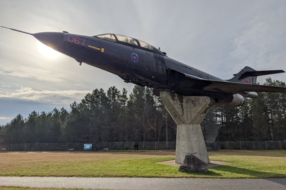
The museum opened in 1998. To access it take Airport Road. Once at the top of the hill, there will be a fork in the road. It is here you will see the Air Defense Park with a mounted Voodoo interceptor jet and some radar equipment, the aerospace museum is in sight.
Keep left on Airport Road. Turn right at the four-way stop (Duxford Rd). This will take you onto Canadian Forces Base North Bay property.
Turn right onto Manston Crescent, and the museum is a grey and blue building with a red stripe, with parking to the left. Visit the aerospace museum near the North Bay airport during its extended summer hours, Wednesday-Friday: 12 - 4 p.m., Saturday: 10 a.m. - 4 p.m. or by appointment or group booking throughout the week. Admission is by donation. Visit it online, here.
Industrial archaeology originated in Great Britain - the birthplace of the Industrial Revolution. We have few preserved examples of the Cold War era. Most are on the back roads, naturally being consumed by time, with only the original black and white photos for a reminder of what was.


